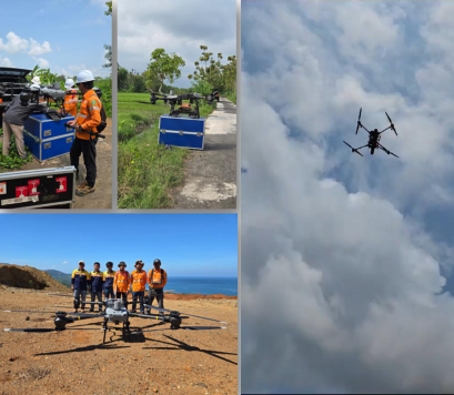
DRONE GPR
PT Geoscan Eksplorasindo, proud to be at the forefront of geological surveying by pioneering the use of Ground Penetrating Radar (GPR) deployed via a large, heavy-lift drone. This cutting-edge approach represents a significant leap forward in efficiency and data quality. By using an airborne platform, we can conduct surveys over large, challenging, or inaccessible terrains far more quickly and
safely than with traditional ground-based methods.
This innovative technology has a proven track record of success in various applications:
Mineral Exploration
Our drone-mounted GPR has been effectively utilized in the exploration of a variety of mineral resources, including silica sand, andesite, and nickel, providing critical subsurface data for resource modeling and planning.
Groundwater Exploration
The technology is also highly successful in groundwater exploration, helping us to efficiently map underground water channels and aquifers to support water resource management projects.
“Drone GPR’s track record reflects the innovation, accuracy and excellence of modern surveying technology.”
2024
Location : Yogyakarta
Effective planning for toll road construction requires a thorough understanding of subsurface conditions. Given that planned routes in Indonesia often cross diverse and challenging terrains—from active rice fields and dense forests to urban settlements—traditional ground-based surveys are often inefficient and disruptive.
To overcome these challenges, PT Geoscan Eksplorasindo utilizes drone-mounted Ground Penetrating Radar (GPR). This innovative technology allows us to conduct rapid, non-intrusive surveys over the entire planned route.
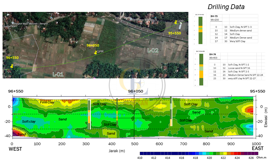
Georadar vertical section compare to drilling data
This advanced method provides critical subsurface information, including:
Geological Structure Identification
We can pinpoint the location of faults, karsts, and other geological structures that could pose a risk to the stability of the road.
Lithology Mapping
The survey helps us to map different rock types and soil layers beneath the surface.
Hard and Soft Rock Volume Calculation
We can accurately calculate the volume of both hard and soft rock, which is essential data for pre-construction planning, excavation cost estimation, and overall project efficiency.
2025
Location : West Kalimantan

This image displays the results of a silica sand exploration survey that we conducted in West Kalimantan in 2025. For this project, we successfully utilized our innovative drone-mounted GPR (Ground Penetrating Radar) technology.
The primary objective was to efficiently map the subsurface distribution of silica sand. As shown in the vertical section, the silica sand deposit is clearly identified as the zone highlighted in red. This high-resolution data provides Silica sand our client with the precise location, depth, and extent of the mineral deposit, which is crucial for resource estimation and mining feasibility planning.