MINERAL EXPLORATION
PT Geoscan Eksplorasindo takes great pride in contributing to Indonesia’s rich mineral wealth. Our participation in this vital sector is driven by our commitment to utilizing cutting-edge technology and the extensive expertise of our professional team.

We have a proven track record of successful exploration projects across the country, providing crucial data for a diverse range of mineral resources, including:
- Metallic Minerals: gold, iron ore, galena, mangan and nickel
- Energy & Industrial Minerals: coal, bauxite, and silica sand
- Construction & Aggregate Materials: andesite, limestone, and marble
Our comprehensive survey capabilities ensure that our clients receive the precise data they need to make informed decisions and advance their exploration and mining projects.
“The following is a series of Mineral Exploration activities by PT Geoscan Eksplorasindo which is an important basis for evaluating mineral potential.”
2020
Location : Aceh – Indonesia
PT Geoscan Eksplorasindo has successfully completed an iron ore exploration project in Subulussalam, Aceh.
We utilized both Induced Polarization (IP) and Resistivity surveys to effectively map the area. Resistivity data provided crucial information on the different rock types and geological structures, while the IP survey was instrumental in identifying the chargeable ore body.
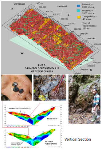
The results of our analysis were presented in three distinct and valuable formats:
Vertical Sections
Cross-sectional views that clearly illustrate the depth, thickness, and orientation of the iron ore deposit.
Planar Maps
Horizontal maps that show the lateral extent and distribution of the mineralized zones.
3D Models
A comprehensive three-dimensional visualization of the iron ore body, which is essential for accurate resource estimation and informed mine planning.
2025
Location : East Kalimantan
In a recent project (2025) conducted in East Kalimantan, we successfully utilized GPR (Ground Penetrating Radar) to identify and map the presence of andesite rock. The data obtained from this survey provided our client with crucial information on the location and extent of this valuable construction material.

The results of our survey were delivered in comprehensive formats, providing the client with a full understanding of the andesite deposit. The deliverables included:
• A vertical section of GPR data that revealed the depth and thickness of the rock layer.
• A planar map showing the horizontal distribution and extent of the andesite.
• A 3D model that provided a complete, volumetric visualization of the deposit, which is essential for accurate resource estimation and mine planning.